There are 121 Shire reserves located within and vested with the Shire of Denmark. 41 reserves are for community oriented services such as drainage, emergency services sites and communications. The remaining 80 reserves have some degree of natural resource management (NRM) input required in order to maintain biodiversity and environmental values. The purpose of these 80 reserves ranges from Conservation, Public Recreation, Parkland Management and resource extraction (gravel and sand). Of these 80 reserves, 12 are classed as A-Class Reserves which secures a higher level of protection of the natural and/or community values.
Coastal Reserves
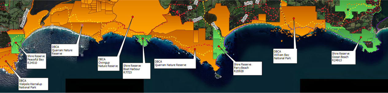
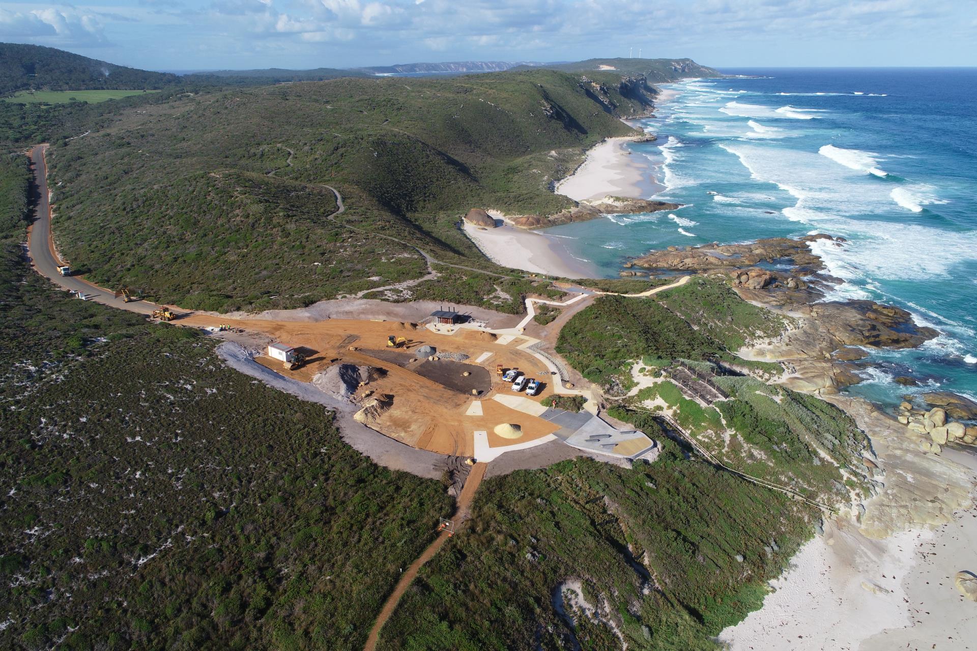
The Shire of Denmark has a coastline covering 84 km. The majority of this land is contained within Conservation Reserves or National Parks, managed by the Department of Parks and Wildlife. The Shire manages four coastal reserves, located at:
- Ocean Beach (614 ha);
- Parry Beach (223 ha);
- Boat Harbour (59 ha); and,
- Peaceful Bay (83 ha).
The Shire’s management of its coastal reserves is detailed in the Coastal Reserves Management Strategy and Action Plan 2010 – 2020. The plan prioritises management recommendations for all four Shire coastal reserves for environmental protection, rehabilitation and future land uses over the next ten years.
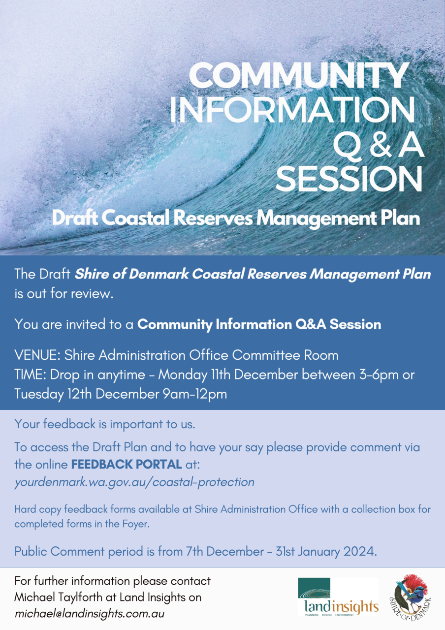
The Draft Shire of Denmark Coastal Reserves Management Plan is out for review. Get involved to have your say towards coastal management for the next ten year Plan.
***Draft Coastal Reserves Management Plan now available for Public Comment.***
Please visit https://www.yourdenmark.wa.gov.au/coastal-protection
The Public Comment Period is NOW OPEN for submissions. Click here to read or download the draft document. Hard copy versions of the draft are also available to view at Shire Administration Building.
To submit your feedback, please share your thoughts via the online Feedback Portal below or write to us:
COASTAL RESERVES MANAGEMENT PLAN COMMUNITY Q&A INFORMATION SESSION!
VENUE: Shire of Denmark Administration Office Committee Room
DATES: Drop in anytime Monday 11th December 3-6pm or Tuesday 12th December 9am-12pm
Your feedback is important to us.
To access the Draft Plan and to have your say please provide comment via the online FEEDBACK PORTAL below.
PUBLIC COMMENT period is OPEN NOW from 7th December 2023 – 31st January 2024.
Hard copy feedback forms available at Shire Administration Office with a collection box for completed forms in the Foyer.
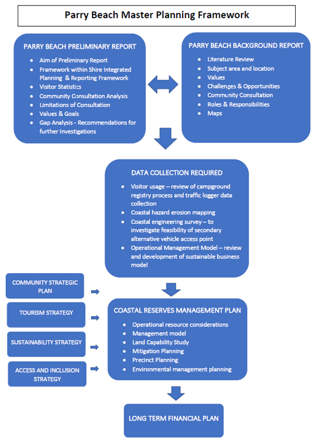
Parry Beach Master Planning
Extensive community consultation was undertaken as part of the Parry Beach Master Planning process conducted in 2021 consisting of a community survey, community forum, and individual targeted engagement with primary stakeholders. There was a substantial response to the community engagement process with 270 respondents to the community survey over a 3 week period and 45 attendees to the community forum, highlighting the significance apportioned to Parry Beach by the broader community. A report of the results of the Parry Beach Master Plan Community Survey is available which outlines demographic statistics, users of the area, primary recreational activity undertaken, and visitor concerns in relation to ongoing use and management.
As part of the community consultation process, a supplementary document was also produced in the form a literature review by engaged consultancy Bio Diverse Solutions; reviewed by members of the Parry Beach Voluntary Management Group, edited by the Shire; and is presented as a supporting document entitled the Parry Beach Background Report.
An analysis of the extensive community consultation from 2021 was then undertaken in-house throughout 2022 to provide consolidated information on the values and issues related to Parry Beach reserve as identified by the community in the form of a preliminary report. The Parry Beach Preliminary Report provides recommendations about further investigations that are required for the development of a comprehensive planning process for Parry Beach. It recommends this process should be incorporated into a review and development of the Shire of Denmark Coastal Reserves Management Plan for all Shire-managed coastal reserves.
The community consultation analysis within the Parry Beach Preliminary Report identified the need for further investigations in order to provide the necessary information towards long-term sustainable management of Parry Beach. One of the recommendations identified from the gap analysis was for coastal hazard erosion mapping to be undertaken for the Parry Beach coastal region, with particular focus on the boat ramp area, with forecasts up to 50-100 years as to retention of beach accessibility into the future.
Parry Beach is not identified yet as a coastal erosion hotspot or on a watchlist site, however the area is recognised by the Shire and community as a unique and incredibly important part of not only our natural landscape, but of our community life as well. Due to the landscape profile consisting of a narrow strip of beach butted up against steep coastal dunes coupled with the high visitor usage and significant value attributed to the area by the community, it is a high profile area of significance for coastal research and planning.
The Shire subsequently (in February 2022) applied to DPLH for two CMPAP grants, one for coastal hazard erosion mapping for Parry Beach and a second submission for a review of the Coastal Reserves Management Plan. In September 2022 the Shire were notified that we were successful to undertake a combined grant project to deliver a coastal reserves management plan with concurrent coastal erosion hazard mapping for Parry Beach to be incorporated into the land use reserve planning for Parry’s.
The development of the Shire of Denmark Coastal Reserves Management Plan will facilitate appropriate management of the coastal reserves into the future taking into account demands from increasing visitor use as well as coastal hazards and coastal erosion processes. The review of the Coastal Reserves Management Strategy and Action Plan (2010-2020) will enable appropriate sustainable longer term management planning in regards site capacity for visitor use and access and associated infrastructure, through provision of prioritised recommendations and management actions to ensure the continued protection and enhancement of the environmental, social, economic and infrastructure asset values of the Shire’s coastal reserves.
Coastal erosion hazard mapping of the Parry Beach reserve planned to be undertaken as part of the grant project will complement and inform the Shire of Denmark Coastal Reserve Management Plan by providing a more detailed understanding of the coastal erosion and climate change impacts of the coastal environs on future sustainable land-use management planning for the reserve.
The Coastal Reserve Management Plan will take direction from the Shire’s Ocean Beach and Peaceful Bay Coastal Hazard Risk Management and Adaptation Plan (2018) as well as the identified findings from the extensive community consultation undertaken in 2021 for Parry Beach reserve as represented within the Parry Beach Preliminary Report (2022). These documents can be accessed under Coastal Documents.
Coastal Hazard Risk Management & Adaptation Planning
Ocean Beach and Peaceful Bay Coastal Hazard Risk Management and Adaptation Plan (2018)
Coastal hazard risk management and adaptation planning is an integral part of decision-making for sustainable development and land use in the coastal zone. The State Coastal Planning Policy 2.6: State Coastal Planning Policy, supports a risk-management approach and provides a framework for undertaking coastal hazard risk management and adaptation planning for coastal hazards in Western Australia.
The Shire’s Coastal Hazard Risk Management and Adaptation Plan (CHRMAP) addresses coastal hazards for two coastal areas:
- Ocean Beach: An east facing high-energy beach adjacent to the mouth of the Wilson Inlet. This is the main recreational beach for the town of Denmark.
- Peaceful Bay: A settlement in the west of the Shire with a sheltered pocket beach (Peaceful Bay) and a longer eroding sandy beach to the east (Foul Bay). Facilities are used by locals, holiday makers and commercial fishers.
The CHRMAP addresses:
- Identification and assessment of coastal hazards
- Establishing the context of coastal asset values and community expectations
- Risk assessment of the potential impact of coastal hazards upon coastal assets
- Adaptation planning for both short term (ten year) and long term (100 year) planning horizons
Ten-year foreshore concept plans for Ocean Beach and Peaceful Bay were developed in conjunction with the CHRMAP, and reflect the community’s aspirations for future development and land use, balanced with the need for coastal hazard adaptation. The plan can be viewed in the Coastal Documents link below.
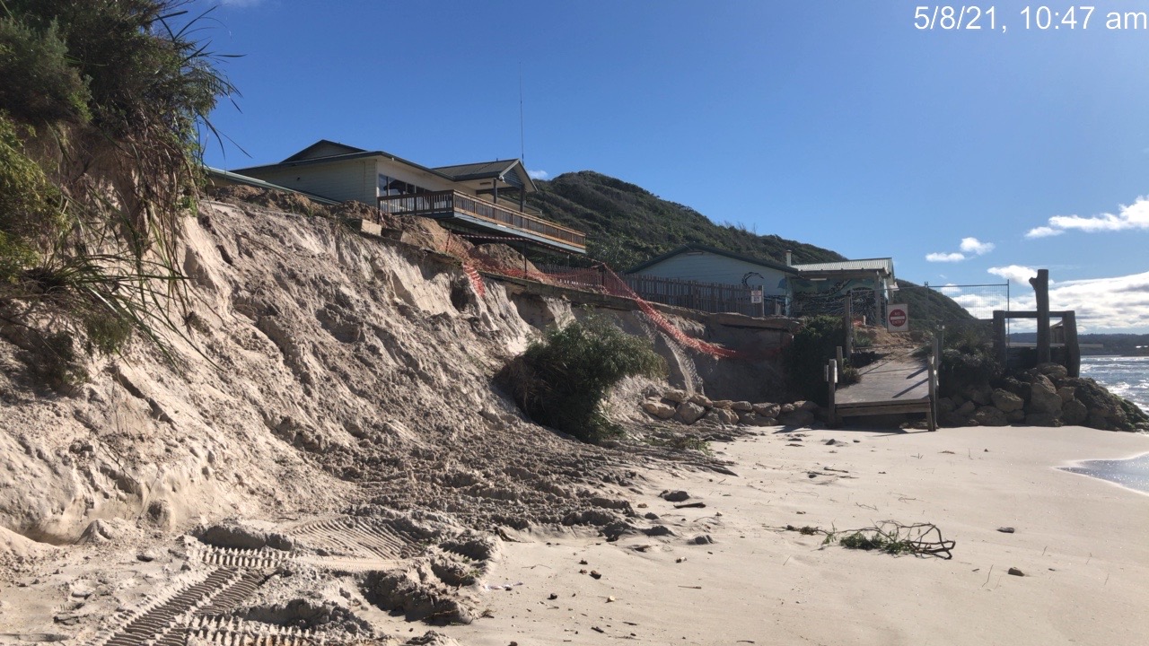
Ocean Beach coastal erosion
Code Off Road
“Code Off Road” – A guide to safe and environmentally responsible coastal 4WD use
South Coast NRM, in partnership with South Coast Management Group, has produced a series of practical maps guiding recreational 4WD use on our coast. The guides cover Denmark, Albany, Bremer Bay, Hopetoun and Esperance and delivers key messages regarding safe and environmentally responsible 4WD drive use, as well as coastal maps. For more information, see the Denmark Code Off Road brochure .
Coastal Documents
Ocean Beach & Peaceful Bay Coastal Hazard Risk Management & Adaptation Plan 2018 -Report
Ocean Beach & Peaceful Bay Coastal Hazard Risk Management & Adaptation Plan 2018 -Appendices
Code of Conduct for Off-Road Driving brochure
Conserving Marine and Coastal Areas Around Denmark brochure
Shire of Denmark Coastal Reserves Management Strategy and Action Plan 2010 – 2020
Coastal Reserve Management and Coastal Erosion Processes
Coastal Hazard Adaptation Concept Planning - Ocean Beach
Assessment of Coastal Erosion Hotspots in Western Australia (2019)
Ocean Beach Geotechnical Survey 2019
Parry Beach Preliminary Report (2022)
Parry Beach Background Report (2022)
Coastal Website links
Lights Beach and Knapp Head
Friends of Reserves Groups
The Shire of Denmark greatly values the contributions of volunteers undertaking bush care activities in bushland, coastal and foreshore reserves vested with the Shire of Denmark and encourages residents who would like to take an active role in reserve management to start their own Friends of Reserve Group. The Shire has developed a Friends of Reserves Strategy to assist these groups and aims to ensure that volunteer bush care activities are undertaken safely and consistent with biodiversity objectives. Please contact the Shire’s Sustainability Officer on phone 9848 0346 if you are interested in forming your own Friends Group or see the documents below.
The Shire supports the activities of community members being part of a Friends of Group to undertake bush care activities on Shire reserves. The following Friends of Groups have the support of the Shire with contact details listed as follows:
Friends of Mt Hallowell (Kooryunderup)
Reserves Documents
Strickland Street Reserve 15513 Karri Walk Trail Brochure
Denmark River Kwoorabup Beelia Mokare Heritage Trail Brochure
Mount Hallowell Reserve Sheila Hill Walk Trail Brochure
Springdale Beach Foreshore Management Plan
Shire of Denmark Reserves Presentation
Conserving Denmark's Terrestrial Environment brochure
Friends of Reserves Groups brochure
Shire of Denmark Friends of Reserves Strategy (2010) Amended 2023
Shire of Denmark Wilson Inlet Foreshore Reserves Management Plan (2008)
Mount Hallowell Reserve Management Plan (2008)
Shire of Denmark Declared Flora Roads Management Plan (2012)
Code of Practice for Roadside Conservation and Maintenance (2012)
State-Managed Reserves
The Shire of Denmark contains a number of national parks, marine parks, conservation parks and nature reserves which are managed by the Department of Parks and Wildlife. These areas can have significance at an international, national, regional and local scale and are important for their biodiversity values, heritage value and tourism. State-managed reserves within the Shire of Denmark includes:
- William Bay National Park
- Mount Lindesay National Park
- Walpole-Nornalup National Park
- Walpole and Nornalup Inlets Marine Park
- Quarram Nature Reserve
- Kordabup Nature Reserve
State-Managed Reserves Documents
Approved Department of Biodiversity Conservation and Attractions (DBCA) Reserves and Parks Management Plans
William Bay National Park Recreation Master Plan